- Boat Insurance
- Boat Browser
- Boating Courses
- Boat Registration
- Boating License
-
Boating Safety
Equipment
| Laurel River Lake
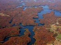
The U.S. Army Corps of Engineers built this reservoir in 1977 on the Laurel River, a tributary of the Cumberland River, in the Daniel Boone National Forest. The Army Corps of Engineers and the Forest Service both work to develop recreational facilities at the reservoir, which is located in Laurel and Whitley counties. Today, the Forest Service manages most of the land as part of Daniel Boone National Forest. The Army Corps of Engineers maintains the operation of the dam and runs recreational facilities at the dam, including a permanent beach.
Fishing |
Search Laurel River Lake Resources |
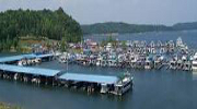
| Boating You have access to eight launch ramps located along the nearly 200 miles of shoreline. The Holly Bay Campground ramp is for the use of registered campers only. Grove Marine and Holly Bay Marina are two full-service marinas owned and operated by private interests. You can rent boats, obtain camping and fishing supplies and licenses, and purchase detailed maps of the lake at both shops. Both marinas are open year round and are handicap accessible.
Boating In Kentucky |
|
Lodging Check the Lake Resources Guide for lodging and campsites. CommunitiesThe closest major city is Lexington. Other nearby Kentucky cities; London, Corbin and Williamsburg. The lake is located in Whitley county. |
Fun times at Laurel River Lake
|
| Average Temperatures | Jan | Feb | Mar | Apr | May | Jun | Jul | Aug | Sep | Oct | Nov | Dec |
|---|---|---|---|---|---|---|---|---|---|---|---|---|
| Avg. High 45 | Avg. High 50 | Avg. High 59 | Avg. High 69 | Avg. High 76 | Avg. High 84 | Avg. High 86 | Avg. High 86 | Avg. High 80 | Avg. High 69 | Avg. High 59 | Avg. High 48 | |
| Avg. Low 26 | Avg. Low 29 | Avg. Low 36 | Avg. Low 45 | Avg. Low 53 | Avg. Low 62 | Avg. Low 66 | Avg. Low 65 | Avg. Low 57 | Avg. Low 45 | Avg. Low 37 | Avg. Low 29 |

 Coordinates:

