
- Boat Insurance
- Boat Browser
- Boating Courses
- Boat Registration
- Boating License
-
Boating Safety
Equipment
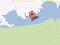
| Nimrod Lake The U.S. Army Corps of Engineers impounded the Fourche LaFave River in 1942, creating Nimrod Lake -- the oldest Corps of Engineers Lake in Arkansas. Snuggled up against the northern boundaries of the Ouachita National Forest, this 3,550-acre lake is noted nationally for its slab crappie fishery. Hunting also is a popular sport around the lake in thousands of acres of project land. Other water sports that visitors enjoy on this lake include water and jet skiing, swimming, pleasure boating, and tubing. Fishing |
Search Nimrod Lake Resources |
 Coordinates:
| Boating Nine boat launch ramps are located on Nimrod Lake and are available all year, but they all require payment of a day-use fee. Annual day use passes are available for individuals who want to revisit the lake regularly. |
|
Lodging Corps of Engineers' recreation areas on Nimrod offer 115 camp sites on four full-service modern campgrounds, which also include playgrounds, swimming areas, fish cleaning stations, and picnic shelters. Quarry Cove and Carter Cove are located on the lake, and Sunlight Bay is located on Wilson Slough just off the Fourche LaFave River upstream from the lake. River Road is on the Fourche LaFave River downstream from Nimrod Dam. Close access to the Ouachita National Forest also provides campers with options in that protected region. The South Fourche Campground is located on Scenic Byway 7, which passes along the eastern end of Lake Nimrod. From the east end of the lake, the campground is just 11 miles into the forest. This scenic byway also leads south to Hot Spring Village and City of Hot Springs, where a large variety of lodging options are available. Hot Springs is located just 51 miles from the middle of Nimrod Lake's northern shoreline. Another town that offers lodging possibilities is Danville, located 19 miles northwest from the lake. Review the Lake Resource Guide for additional lodging. Communities Nimrod Lake, located in Yell County, Arkansas, is close to Danville, Nimrod, Plainview, and Rover. Hot Springs is a little over an hour's drive to the south, and that resort town offers a small regional airport. Little Rock, located 72 miles to the southeast, provides a larger airport. |
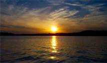
Fun times at Nimrod Lake
|
| Average Temperatures | Jan | Feb | Mar | Apr | May | Jun | Jul | Aug | Sep | Oct | Nov | Dec |
|---|---|---|---|---|---|---|---|---|---|---|---|---|
| Avg. High 50 | Avg. High 55 | Avg. High 64 | Avg. High 73 | Avg. High 80 | Avg. High 87 | Avg. High 92 | Avg. High 92 | Avg. High 84 | Avg. High 74 | Avg. High 62 | Avg. High 51 | |
| Avg. Low 28 | Avg. Low 31 | Avg. Low 38 | Avg. Low 47 | Avg. Low 57 | Avg. Low 65 | Avg. Low 70 | Avg. Low 68 | Avg. Low 60 | Avg. Low 49 | Avg. Low 39 | Avg. Low 30 |