
- Boat Insurance
- Boat Browser
- Boating Courses
- Boat Registration
- Boating License
-
Boating Safety
Equipment
| Lake Ouachita The U.S. Army Corps of Engineers completed the Blakely Mountain Dam in 1954, impounding the Ouachita River and creating the reservoir known today as Lake Ouachita. Approximately 1.2 million people visit this reservoir every year to enjoy the 20,000 acres of public land and the boating, fishing, and camping along 690 miles of shoreline. Located near the Hot Springs, Arkansas resort spa, Lake Ouachita is popular for scuba diving as the water is so clear. This reservoir has over 40,000 surface acres, and it is the largest lake that is completely in Arkansas. As one of the few clean freshwater lakes in the country, Lake Ouachita has rare non-stinging jellyfish and sponges. Fishing |
Search Lake Ouachita Resources |
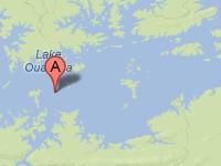 Coordinates:
| Boating Boaters can take advantage of approximately nine marinas as well as at least eighteen boat ramps maintained by the Corps on Lake Ouachita. Seven of these recreation areas maintained by the Corps also have fish cleaning stations, and one area -- Stephens-Avery -- also has a fishing dock. If you're not using your boat to fish, ski, or dive, you might want to take the boating trail around the lake to view geological formations along the shoreline. Be aware that this lake's depth can quickly go from over 150 feet to two feet quickly, especially near the shoreline. This is part of what makes this lake exceptional for bass fishing, but it also can tear up a boat. The water is exceptionally clear, which helps to gauge some depths. |
|
Lodging The Corps of Engineers maintains over 1100 campsites at eighteen out of twenty recreation areas around this lake. Some are fairly primitive camp sites, while others have electric hookups and lodging as well. For visitors who prefer state parks, Lake Ouachita State Park is nestled in the Ouachita National Forest and offers 103 camp sites and fully-equipped cabins that overlook the lake. This park also offers a swimming area, trails, and a marina that provides boat rentals, bait, and supplies.
If you don't mind driving an hour to lodge at Hot Springs, Arkansas, you can find a wealth of places to stay as well as things to do. Choose among hotels, spas, resorts, condos, temporary vacation homes, cabins, and B&Bs for a relaxing experience in a town so close to the national forest. Review the Lake Resource Guide for additional lodging. Communities Lake Ouachita sits in the Ouachita National Forest across Montgomery and Garland Counties in Arkansas. Located just ten miles west from Hot Springs, Arkansas, this lake provides the ideal getaway. Although Hot Springs, located just one hour from the lake, has an airport, the service is limited. The largest city close to the lake is Little Rock at 56 miles from Hot Springs. That city maintains an airport that is served by six airlines to a number of national and international destinations with non-stop jet service. |
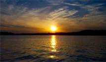
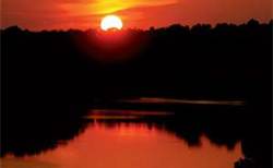
Fun times at Lake Ouachita
|
| Average Temperatures | Jan | Feb | Mar | Apr | May | Jun | Jul | Aug | Sep | Oct | Nov | Dec |
|---|---|---|---|---|---|---|---|---|---|---|---|---|
| Avg. High 51 | Avg. High 55 | Avg. High 63 | Avg. High 72 | Avg. High 87 | Avg. High 91 | Avg. High 91 | Avg. High 91 | Avg. High 84 | Avg. High 74 | Avg. High 62 | Avg. High 52 | |
| Avg. Low 28 | Avg. Low 31 | Avg. Low 38 | Avg. Low 45 | Avg. Low 55 | Avg. Low 62 | Avg. Low 66 | Avg. Low 65 | Avg. Low 58 | Avg. Low 47 | Avg. Low 38 | Avg. Low 30 |