
- Boat Insurance
- Boat Browser
- Boating Courses
- Boat Registration
- Boating License
-
Boating Safety
Equipment
| Bull Shoals Lake Bull Shoals Lake, found in Northern Arkansas and Southern Missouri amidst the Ozark Mountains, covers 45,440 acres of water controlled by the Army Corps of Engineers. In a chain of four man-made lakes which include Arkansas' Beaver Lake, Table Rock Lake, which lies in both Arkansas and Missouri, and Missouri's Lake Taneycomo, Bull Shoals Lake is the farthest downstream. Originally built for flood control, Bull Shoals Lake provides year-round recreational opportunities. More than29,000 acres of deep, clear, blue waters in Arkansas, Bull Shoals Lake attracts water sports' lovers looking for alluring opportunities to go boating, water skiing, wake boarding, sailing, scuba diving, swimming and fishing. The area around Bull Shoals Lake on the Missouri side offers opportunities for hunting, hiking, horseback riding, and camping. Fishing Some of the most sought after fish in Bull Shoals Lake include largemouth and smallmouth bass, black bass, white bass, striped bass, bluegill, bream and crappie. Night fishing yields good catches of stripers, walleye and trout. Bull Shoals Lake holds several state records for producing the largest of several fish species caught in Arkansas and Missouri. Such records include: a 13-pound 14-ounce Largemouth Bass caught in 1961; a seven-pound five-ounce Smallmouth Bass caught in 1969; a five-pound four-ounce White Bass and a seven-pound 15-ounce Spotted Bass caught in 1983; a 21-pound one-ounce Walleye caught in 1988; a 27 pound Gar caught in 1999; a one-pound 11-ounce Yellow Perch caught in 2009, and most recently, a 60-pound nine-ounce Striped Bass caught in 2011. In addition to the fish caught in the lake, Bull Shoals Lake holds several Arkansas and Missouri state records for cutthroat and rainbow trout, which gives it recognition as a prime fishery. |
Search Bull Shoals Lake Resources |
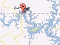 Coordinates:
| Boating Bull Shoals Lake welcomes all boat and motor types and sizes. There are a number of public access boat ramps along the lake for easy access to the water. Several full-service marinas provide boat rentals, fishing guides, fishing supplies, fuel, storage and groceries. Many of the lakeside resorts offer boat ramps and marine supplies, as well. |
|
Lodging Bull Shoals Lake lodging options include campgrounds and a variety of facilities available near and around the lake. Please consult the Lake Resource Guide for information on lodging and other facilities in the area. Communities The closest major Arkansas city to Bull Shoals Lake is Fayetteville, which is 132 miles away. Closer cities and towns in Arkansas: Mountain Home, Harrison, Batesville, Russellville and Springdale. Bull Shoals Lake flows through parts of Baxter and Marion counties. |
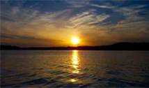
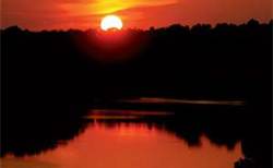
Fun times at Bull Shoals Lake
|
| Average Temperatures | Jan | Feb | Mar | Apr | May | Jun | Jul | Aug | Sep | Oct | Nov | Dec |
|---|---|---|---|---|---|---|---|---|---|---|---|---|
| Avg. High 45 | Avg. High 48 | Avg. High 60 | Avg. High 70 | Avg. High 77 | Avg. High 85 | Avg. High 90 | Avg. High 88 | Avg. High 82 | Avg. High 72 | Avg. High 58 | Avg. High 48 | |
| Avg. Low 22 | Avg. Low 26 | Avg. Low 36 | Avg. Low 46 | Avg. Low 55 | Avg. Low 62 | Avg. Low 67 | Avg. Low 65 | Avg. Low 58 | Avg. Low 47 | Avg. Low 37 | Avg. Low 27 |