- Boat Insurance
- Boat Browser
- Boating Courses
- Boat Registration
- Boating License
-
Boating Safety
Equipment
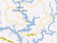
| Lewis Smith Lake Lewis Smith Lake, known as Smith Lake, is a reservoir located on the Sipsey Fork of the Black Warrior River. The lake covers over 21,000 acres in three counties, and it has over 500 miles of shoreline and an amazing maximum depth of 264 feet. Alabama Power created the Lewis Smith Dam, one of the largest earthen dams in the eastern U.S., and completed construction in 1961.
Fishing |
Search Lewis Smith Lake Resources |
| Boating Public use areas, which include boat launch ramps, are numerous. With this lake's proximity to William Bankhead National Forest and the Sipsey Wilderness Area, as well as to Birmingham and Huntsville, the lake has become a popular second-home location. Several county roads cross the lake in every location, making the shoreline easy to access. Smith Lake Park, owned by Cullman County, offers a new ADA-compliant dock. |
|
|
Lodging Although Lewis Smith Lake is far from any state park, visitors can find camping, cabins, and lake house rentals along this lake's shorelines and at William B. Bankhead National Forest on the western end of the lake. Lodging also is available along I-65, which is a short five miles from the eastern shores of the lake.
Review the Lake Resource Guide for additional lodging. Communities Lewis Smith Lake covers Walker, Winston, and Cullman Counties in Alabama, and is located less than an hour's drive from Birmingham. Other towns close to the lake include Cullman, Hanceville, and Warrior. |
Fun times at Lewis Smith Lake
|
| Average Temperatures | Jan | Feb | Mar | Apr | May | Jun | Jul | Aug | Sep | Oct | Nov | Dec |
|---|---|---|---|---|---|---|---|---|---|---|---|---|
| Avg. High 52 | Avg. High 57 | Avg. High 66 | Avg. High 74 | Avg. High 81 | Avg. High 87 | Avg. High 90 | Avg. High 91 | Avg. High 85 | Avg. High 75 | Avg. High 65 | Avg. High 55 | |
| Avg. Low 29 | Avg. Low 32 | Avg. Low 39 | Avg. Low 46 | Avg. Low 56 | Avg. Low 64 | Avg. Low 69 | Avg. Low 67 | Avg. Low 60 | Avg. Low 48 | Avg. Low 38 | Avg. Low 32 |

 Coordinates:

